Highlights:
- High density of strong magnetic anomalies that are interpreted as the signatures of mafic and ultramafic formations.
- The newly discovered gossan zone is situated in close proximity to these anomalies, emphasizing the favorable environment for base metals mineralization.
- A HELITEM2 survey to identify massive sulfide mineralization and covering the entire property is due to start before the end of the year.
Montréal, Quebec, November 02, 2021 – Sama Resource Inc (“Sama” or the “Company”) (TSX-V: SME | OTC-PK: SAMMF) is pleased to reportthatSama Resources Québec Inc. (“SRQ”) a fully own subsidiary of the Company has announced the completion and interpretation of an unmanned aerial vehicle (UAV) magnetic and radiometric survey of 609 line-kilometres (line-km) over the core of the new Lac Brulé nickel-copper property and including the gossan discovered in May 2021 (ref: PR 2021-06-16). (Gossans are highly ferruginous rock which is the product of the oxidation by weathering and leaching of a sulfide body: Elsevier Mineral Exploration 2013).
As a part of the ongoing exploration program, SRQ commissioned Helios UAV to complete a high-resolution magnetic and radiometric survey over the Lac Brûlé Property, located 290 km north-west of Montreal, Quebec province, Canada and easily accessible by roads. The UAV survey took place from July 14 through August 3, 2021 and included the acquisition of 609 line-km of magnetic data and of 335 line-km of radiometric data. Interpretation was performed by M. Joel Simard, P. Geol./Geoph based in St-Donat, Quebec province, Canada.
No historical prospecting or ground exploration had been reported from the Lac Brulé area prior to SRQ. However, Government regional magnetic and gravity maps covering the area, as part of coverage of the entire Quebec province, as well as data from stream and lake sediment sampling programs covering the entire province, are available on the SIGEOM website.
The past-producing Renzi nickel-copper mine is the closest mining activity with historical information available. The Renzi mine is located 48 km east-southeast of the Lac Brulé property. The Company is targeting possible accumulations of Ni and Cu mineralisation at Lac Brulé that could be of similar nature to that at the Renzy mine and at other well-known Ni-Cu deposits in Québec and Labrador.
Geophysical Program
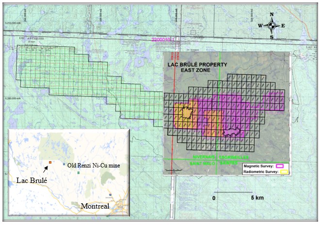
The UAV magnetic survey covered the east-central part of the Lac Brulé property with north-south oriented lines at 100 m spacing (see Figure 1) for a total of 609-line km. The aim was to use the survey to assist with structural and geological mapping, and in particular to delineate the mafic/ultramafic units that host mineralisation at the gossan.
Figure 1: Map of MAG survey completed by Helios UAV.
The survey maps show a high density of strong magnetic anomalies that are interpreted as the signature of mafic and ultramafic formations. The gossan zone is situated in the vicinity of these anomalies, emphasizing the favourable environment for base metals mineralization.
The discovery zone, where the gossans have been identified, is situated in the vicinity of strong magnetic anomalies in the south-central part of the block that was flown (Figures 2 & 3). This gossan zone lies along a localized northwest to north-northwest trending discontinuity (fault) where the magnetic units appear locally demagnetized. Demagnetization is potentially indicative of alteration caused by the upwelling of hydrothermal fluids along the fault. This structural control may emphasize other favorable locations to search for precious and base metals mineralization (Figure 4).
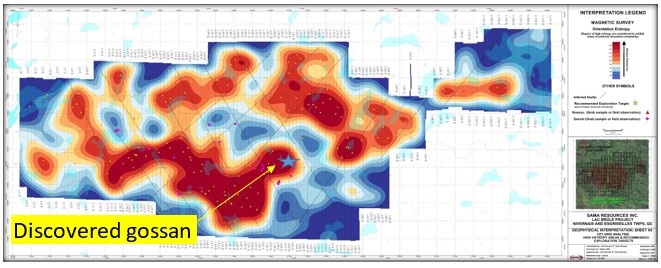
The delineation of linear discontinuities over the survey area was achieved by using a program from the Centre for Exploration Targeting (CET), a joint initiative between Curtin University and the University of Western Australia (Figure 5). The CET method enhances discontinuities within aeromagnetic datasets that usually correspond with, and can reveal, lithological boundaries, faults, and dykes/intrusions critical to understanding the geology of an area.
Figure 2: Total Magnetic Field for the UAV MAG survey.
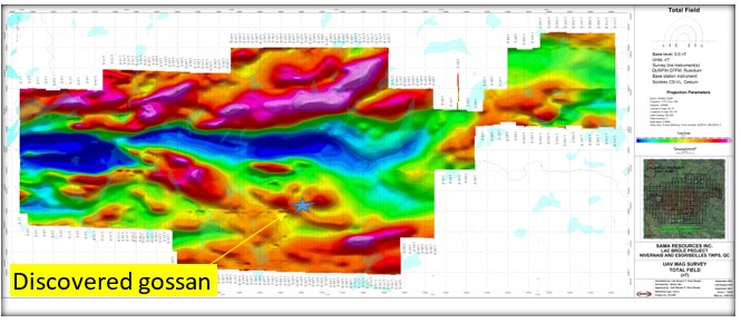
Figure 3: Using the tilt derivative filter, the positive magnetic anomalies were delineated regardless of their relative amplitude. In the survey area, the calculated depths range from sub-outcropping to slightly more than 1500 m, with a mean value of 60 m.
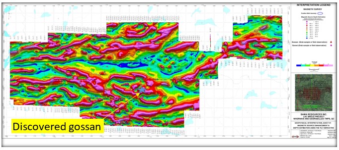
Figure 4: The main magnetic anomalies are linked to relatively broad bands of rocks that are 50 m wide and can reach up to 300 m in apparent thickness (top). The gossan zone is observed on a localized low magnetic feature which seems to coincide with the trace of a northwest to north-northwest striking fault causing local demagnetization of the host mafic and ultramafic units (bottom).
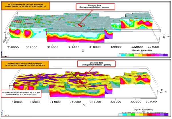
Figure 5: CET: Grid Analysis, High Entropy Areas and Recommended Exploration Target areas.
Readers are invited to view the updated Corporate Presentation showing exploration progress at all our properties : https://samaresources.com/i/pdf/Sama_Corporate_Presentation.pdf
The technical information in this release has been reviewed and approved by Dr. Marc-Antoine Audet, P.Geo and President and CEO of Sama, and a ‘qualified person’, as defined by National Instrument 43-101 Standards of Disclosure for Mineral Projects.
ABOUT SAMA RESOURCES INC.
Sama is a Canadian-based mineral exploration and development company with projects in West Africa and now in Canada.
In Côte d’Ivoire only, Sama, has a strategic partnership to develop the Samapleu-Yepleu nickel-copper-palladium project with Ivanhoe Electric (previously HPX) of which mining entrepreneur Robert Friedland is a significant stakeholder. For more information about Sama, please visit Sama’s website at https://samaresources.com.
FOR FURTHER INFORMATION, PLEASE CONTACT:
SAMA RESOURCES INC./RESSOURCES SAMA INC.
Dr. Marc-Antoine Audet, President and CEO
Tel:(514) 726-4158
OR
Mr. Matt Johnston, Corporate Development Advisor
Tel: (604) 443-3835
Toll Free: 1 (877) 792-6688, Ext. 5
Neither the TSXV nor its Regulation Services Provider (as that term is defined in the policies of the TSXV) accepts responsibility for the adequacy or accuracy of this release.
Forward-Looking Statements
Certain of the statements made and information contained herein are “forward-looking statements” or “forward-looking information” within the meaning of Canadian securities legislation. Forward-looking statements and forward-looking information such as “evidence”, “potential”, “appears”, “seems”, “suggest”, are subject to a variety of risks and uncertainties which could cause actual events or results to differ from those reflected in the forward-looking statements or forward-looking information, including, without limitation, the availability of financing for activities, risks and uncertainties relating to the interpretation of drill results and the estimation of mineral resources and reserves, the geology, grade and continuity of mineral deposits, the possibility that future exploration, development or mining results will not be consistent with the Company’s expectations, metal price fluctuations, environmental and regulatory requirements, availability of permits, escalating costs of remediation and mitigation, risk of title loss, the effects of accidents, equipment breakdowns, labour disputes or other unanticipated difficulties with or interruptions in exploration or development, the potential for delays in exploration or development activities, the inherent uncertainty of cost estimates and the potential for unexpected costs and expenses, commodity price fluctuations, currency fluctuations, expectations and beliefs of management and other risks and uncertainties.
In addition, forward-looking statements and forward-looking information are based on various assumptions. Should one or more of these risks and uncertainties materialize, or should underlying assumptions prove incorrect, actual results may vary materially from those described in forward-looking information or forward-looking statements. Accordingly, readers are advised not to place undue reliance on forward-looking statements or forward-looking information. Except as required under applicable securities legislation, the Company undertakes no obligation to publicly update or revise forward-looking statements or forward-looking information, whether as a result of new information, future events or otherwise.